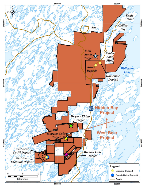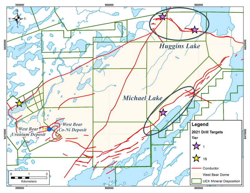


Saskatoon, Saskatchewan - TheNewswire - April 21, 2021 - UEX Corporation (TSX:UEX) (OTC:UEXCF) (“UEX” or the “Company”) is pleased to announce additional cobalt-nickel assay results from the winter drill program at Michael Lake on the West Bear Property (Figures 1 & 2). This winter, UEX completed 19 drill holes totaling 2,690 m at Michael Lake.
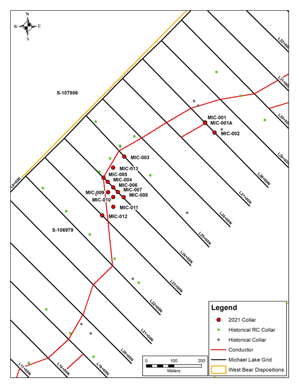
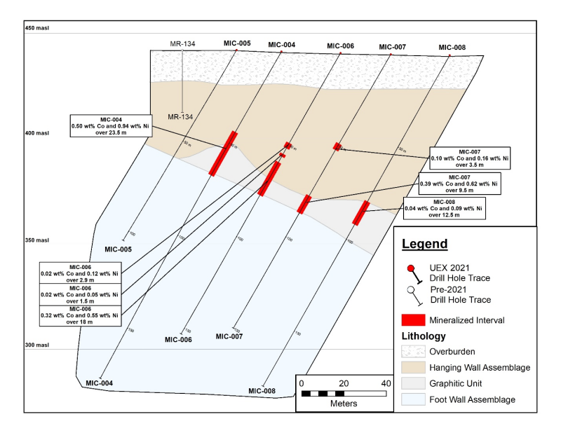
Drill hole MIC-006 intersected mineralization that averaged 0.32% Co and 0.55% Ni over 18.0 m from 59.5 to 77.5 m within altered basement rocks, which included a subinterval averaging 1.09% Co and 1.13% Ni over 2.5 m (from 73.0 to 75.5 m). MIC-006 tested the area approximately 25 m down-dip of hole MIC-004 at a vertical depth of between 52 to 67 m below surface between holes MIC-004 & MIC-007 (Figure 3 & 4).
Drill hole MIC-009 was drilled to test the area approximately 25 m along strike to the grid south of MIC-006 (Figure 3) and encountered cobalt-nickel mineralization in several intervals. The best interval averaged 0.37% Co and 0.33% Ni over 8.0 m from 68.0 to 76.0 m within altered basement rocks and includes a high-grade subinterval of cobalt-nickel mineralization that averages 1.76% Co and 1.38% Ni over 1.5 m from 70.5 to 72.0 metres.
Drill hole MIC-010 was collared 25 m down dip of MIC-009 and intersected cobalt-nickel mineralization grading 0.22% Co and 0.33% Ni over 22.0 m from 61.5 to 83.5 m including a sub interval of high-grade mineralization grading 2.02% Co and 2.70% Ni over 2.0 m from 81.0 to 83.0 metres. The high-grade mineralization remains open at depth on Section 23+75N.
MIC-011 was collared on Section 23+50N and represents a 25 m step grid south from MIC-009 & MIC-010. This hole encountered cobalt-nickel mineralization over several intervals, the widest of which was 9.3 m that graded 0.02% Co and 0.04% Ni from 50.0 to 59.3 metres. Given the distance from the controlling structure, these grades are encouraging as there is room for additional drilling on this section up dip of MIC-011 towards the controlling structure.
MIC-013 collared on section 24+50N, approximately 50 m along strike of MIC-005 as a shallow test of the width of this plunging mineralized system. MIC-013 encountered cobalt-nickel mineralization averaging 0.03% Co and 0.08% Ni over 17.0 metres.
The current assay results are encouraging as this new zone of cobalt-nickel mineralization at Michael Lake remains open for expansion in all directions.
Michael Lake Assay Results from drill holes MIC-006, MIC-009, MIC-010, MIC-011, & MIC-013
|
Hole |
Depth |
Core Length |
Cobalt |
Nickel |
||
|
From (m) |
To (m) |
(m*) |
(wt%t) |
(wt%t) |
||
|
MIC-006 |
49.1 |
52.0 |
2.9 |
0.02 |
0.12 |
|
|
55.0 |
56.5 |
1.5 |
0.02 |
0.05 |
||
|
59.5 |
77.5 |
18.0 |
0.32 |
0.55 |
||
|
including |
73.0 |
75.5 |
2.5 |
1.09 |
1.13 |
|
|
MIC-009 |
36.7 |
38.0 |
1.3 |
0.07 |
0.16 |
|
|
58.5 |
60.5 |
2.0 |
0.04 |
0.08 |
||
|
68.0 |
76.0 |
8.0 |
0.37 |
0.33 |
||
|
including |
70.5 |
72.0 |
1.5 |
1.76 |
1.38 |
|
|
MIC-010 |
61.5 |
83.5 |
22.0 |
0.22 |
0.33 |
|
|
including |
73.5 |
83.5 |
10.0 |
0.46 |
0.66 |
|
|
and |
81.0 |
83.0 |
2.0 |
2.02 |
2.70 |
|
|
MIC-011 |
50.0 |
59.3 |
9.3 |
0.02 |
0.04 |
|
|
76.0 |
77.0 |
1.0 |
0.02 |
0.04 |
||
|
78.0 |
80.5 |
2.5 |
0.03 |
0.04 |
||
|
MIC-013 |
26.5 |
43.5 |
17.0 |
0.03 |
0.08 |
|
|
including |
26.5 |
29.0 |
2.5 |
0.07 |
0.19 |
|
|
* True widths are estimated to be >90% of core length |
||||||
|
t Composite assays calculated using a cut-off grade of 0.023% CoEq where CoEq=Co%+(Ni%x0.2) |
||||||
The actual dip of the mineralization has yet to be confirmed. However, mineralized core lengths reported in this news release are expected to be greater than 90% of the core length based on core measurements and the dip of the drill hole.
The assay results of holes MIC-006 through MIC-013 were important in establishing the growth potential of our new cobalt-nickel discovery at Michael Lake. We eagerly await remaining assay results from the winter drill program. The onset of the spring thaw has forced the Company to suspend exploration drilling. Follow-up drilling of this new zone will be a high-priority for the Company when UEX is able to re-access the Michael Lake area.
-
--Roger Lemaitre, President & CEO
UEX also completed 6 drill holes totalling 753 m testing exploration targets in the Uranium-Nickel Sands target on the adjacent Hidden Bay Project before the termination of the winter drill program (Figure 1). UEX has now demobilized its crews from the field for the spring thaw which is now underway in northern Saskatchewan. Assay results from several holes from the winter program have yet to be received from the laboratory.
Sample Collection and Compositing
Samples for assaying are selected using a portable X-Ray Fluorescence (“XRF”) Spectrometer to aid in the identification of mineralized intervals. Selected drill core is then split in half sections on site and one half is collected for analysis with the other half core remaining on site for reference. Where possible, samples are collected at a standardized 0.5 m interval through zones of mineralization but respect geological units and intervals.
The samples are shipped to the Geoanalytical Laboratory at the Saskatchewan Research Council (“SRC”) in Saskatoon, Saskatchewan. Analysis at the SRC laboratory for Cobalt and Nickel was completed using the ICP-OES method with an Aqua Regia digestion. The SRC Geoanalytical Laboratory is an ISO/IEC 17025:2005 accredited facility (#537) by the Standards Council of Canada.
Assay intervals were composited using a cut-off grade of 0.023% Cobalt equivalent (CoEq) using the equation CoEq = Co + (Ni x 0.2). All depth measurements and sample intervals reported are down-hole measurements from drill core.
Qualified Persons and Data Acquisition
The technical information in this news release has been reviewed and approved by Roger Lemaitre, P.Eng., P.Geo., UEX’s President and CEO, and Chris Hamel, P.Geo., UEX’s Exploration Manager, who are each considered to be a Qualified Person as defined by National Instrument 43-101.
About the West Bear Cobalt-Nickel Project
The West Bear Property is an advanced exploration project located in the eastern Athabasca Basin of northern Saskatchewan, Canada that contains both the West Bear Cobalt-Nickel Deposit and the West Bear Uranium Deposit. The Property is approximately 740 kilometres north of Saskatoon, west of Wollaston Lake and measures approximately 11,104 hectares comprising of 27 contiguous areas to which UEX has 100% ownership, with the exception of Mineral Lease 5424 in which UEX owns a 77.575% interest. The Deposit is located within an area of the Athabasca Basin that has excellent infrastructure and is situated within 10 kilometres of an existing all-weather road and power lines that service Cameco Corporation’s nearby Cigar Lake Mine and Rabbit Lake Operation, as well as Orano’s McClean Lake Operation.
The West Bear Cobalt-Nickel Deposit currently has a strike length of over 600 metres and a dip length of over 100 metres. On April 15, 2020, the Company announced an updated indicated resource estimate for the Deposit of 1,223,000 tonnes grading 0.19% cobalt and 0.21% nickel, which equates to 5,122,000 pounds of cobalt and 5,662,000 pounds of nickel The West Bear Cobalt-Nickel Deposit mineral resources were determined using a cut-off grade of 0.023 percent cobalt equivalent (“CoEq”), using the equation CoEq = Co + (Ni x 0.2).
The West Bear Uranium Deposit has been defined over a strike length of 530 m, ranges in width between 20 m and 70 m, ranges in thickness from 0.1 m to over 15 m and is located at vertical depths between 15 m to 35 m. The WBU Deposit is a classic cigar-shaped body similar to the Cigar Lake and McClean Lake deposits and is hosted at and above the intersection of faulted graphitic metapelites at the unconformity with the overlying Athabasca Group sandstone.
About UEX
UEX (TSX:UEX, OTCQB:UEXCF, UXO.F) is a Canadian uranium and cobalt exploration and development company involved in an exceptional portfolio of uranium projects, including a number that are 100% owned and operated by UEX, one joint venture with Orano Canada Inc. (“Orano”) and ALX Uranium Corp. (“ALX”) that is 51.43% owned by UEX, as well as eight joint ventures with Orano, one joint venture with Orano and JCU (Canada) Exploration Company Limited, which are operated by Orano, and one project (Christie Lake), that is 65.55% owned by UEX with JCU (Canada) Exploration Company Limited which is operated by UEX.
The Company is also leading the discovery of cobalt in Canada, with three cobalt-nickel exploration projects located in the Athabasca Basin of northern Saskatchewan, including the only primary cobalt deposit in Canada. The 100% owned West Bear Project was formerly part of UEX’s Hidden Bay Project and contains the West Bear Cobalt-Nickel Deposit and the West Bear Uranium Deposit. UEX also owns 100% of two early stage cobalt exploration projects, the Axis Lake and Key West Projects.
Our portfolio of projects is located in the eastern, western and northern perimeters of the Athabasca Basin, the world's richest uranium belt, which in 2019 accounted for approximately 12.6% of the global primary uranium production. UEX is currently advancing several uranium deposits in the Athabasca Basin which include the Christie Lake deposits, the Kianna, Anne, Colette and 58B deposits at its currently 49.1%-owned Shea Creek Project (located 50 kilometres north of Fission’s Triple R Deposit and Patterson Lake South Project, and NexGen’s Arrow Deposit), the Horseshoe and Raven deposits located on its 100%-owned Horseshoe-Raven Development Project and the West Bear Uranium Deposit located at its 100%-owned West Bear Project.
FOR FURTHER INFORMATION PLEASE CONTACT
Roger Lemaitre
President & CEO
(306) 979-3849
Forward-Looking Information
This news release contains statements that constitute "forward-looking information" for the purposes of Canadian securities laws. Such statements are based on UEX's current expectations, estimates, forecasts and projections. Such forward-looking information includes statements regarding the West Bear Co-Ni Property, the Christie Lake Property drill program, the Hidden Bay Property, the Shea Creek Property, UEX's drill hole results, uranium, cobalt and nickel prices, outlook for our future operations, plans and timing for exploration activities, and other expectations, intentions and plans that are not historical fact. Such forward-looking information is based on certain factors and assumptions and is subject to risks, uncertainties and other factors that could cause actual results to differ materially from future results expressed or implied by such forward-looking information. Important factors that could cause actual results to differ materially from UEX's expectations include uncertainties relating to the, interpretation of drill results and geology, assay confirmation, additional drilling results, continuity and grade of deposits, fluctuations in uranium, cobalt and nickel prices and currency exchange rates, changes in environmental and other laws affecting uranium, cobalt and nickel exploration and mining, and other risks and uncertainties disclosed in UEX's Annual Information Form and other filings with the applicable Canadian securities commissions on SEDAR. Many of these factors are beyond the control of UEX. Consequently, all forward-looking information contained in this news release is qualified by this cautionary statement and there can be no assurance that actual results or developments anticipated by UEX will be realized. For the reasons set forth above, investors should not place undue reliance on such forward-looking information. Except as required by applicable law, UEX disclaims any intention or obligation to update or revise forward-looking information, whether as a result of new information, future events or otherwise.
Figure 1 - The Hidden Bay & West Bear Projects
Figure 2 - The Huggins/Michael Lakes Area
Figure 3 - Michael Lake Drill Hole Location Map
Figure 4 – Mineralized Intervals & Simplified Preliminary Geology for Section 24+00N
Copyright (c) 2021 TheNewswire - All rights reserved.


